Traffic information

For traffic information to benefit from the advances of digital technology, it is necessary to develop systems that can both predict the occurrence of events and transmit information to users. So-called cooperative systems allow data to be exchanged between vehicles and the infrastructure and thus improve the usefulness and dissemination of services. The work of a number of IFSTTAR researchers has helped to develop innovative services that enable drivers to adjust their speed or predict their travel time.

The objective of the project was to further knowledge in the area of cooperative ITS systems (C-ITS) in order to meet the transport needs of cities for improved and more sustainable transport. This project permitted the monitoring and evaluation of C-ITS under operational conditions in two real urban environments, Helmond and Bordeaux, by expanding the number of users and the geographical coverage of existing systems. A comprehensive impact study was conducted to determine the benefits of C-ITS systems in terms of traffic efficiency, safety and environmental impact, as well as user acceptance.

The deployed services were as follows:
1. GLOSA (Green Light Optimisation Service Advisory);
2. RLVW (Red Light Violation Warning);
3. IVS (In-Vehicle Signalling);
4. P+R (Park & Ride Information).

The C–The Difference pilot project delivers a comprehensive and integrated impact assessment of C-ITS services on the basis of 18 months’ operation of existing and new C-ITS services with private and professional users in urban areas. For GLOSA, more than 1,500 traffic signals were connected together in Bordeaux. Acceptability studies show that drivers reported adjusting their speed and slowing down more smoothly when approaching the traffic signal. During the trial, no improvement was observed in traffic efficiency or throughput due to the low penetration rate even if more than 800 users used the app. But the collected data shows that using GLOSA can help to achieve constant journey times which helps both users and road operators in their daily travel and in surveillance activities.

C-ITS services displayed on a smartphone

Validation of a prototype for estimating journey times on the A35 (through Strasbourg)

The A35 motorway is a strategic link for the Strasbourg Eurometropolis. It not only carries through traffic but also facilitates internal trips within the urban community of Strasbourg. It carries heavy traffic and generates many negative environmental and economic externalities: recurrent congestion which leads to delays and undermines economic competitiveness, noise problems, and air pollution which causes nearly 150 premature deaths per year.

DREAL Grand Est, which is responsible for the project management of the upgrading of this road, has contacted IFSTTAR in order to:

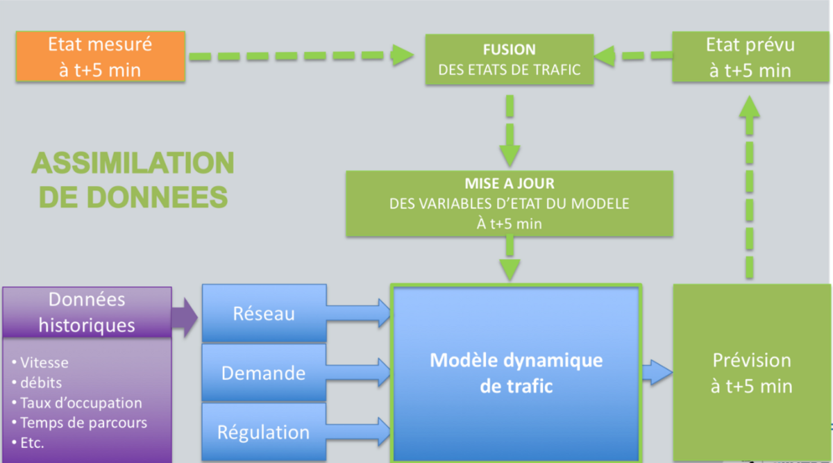
  • Conduct a feasibility study detailing the design of a prototype for short-term journey time forecasting on this portion of the A35,
  • Develop a prototype that provides real-time knowledge of traffic conditions and that makes short-term traffic predictions, in order to compute journey time information reliably and disseminate it to users,
  • Validate the prototype based on historical observations. It has been shown to be robust as regards integrating specific events that regularly occur on the network (accidents, works).

This work provided an opportunity to test the journey time estimation prototype developed at IFSTTAR between 2015 and 2017, under real conditions in the field. This first application validated the functionalities provided by the algorithms developed within this framework and led to an initial proof of concept before subsequent deployment.

Diagrammatic representation of the operation of the journey time estimation prototype